The project in brief
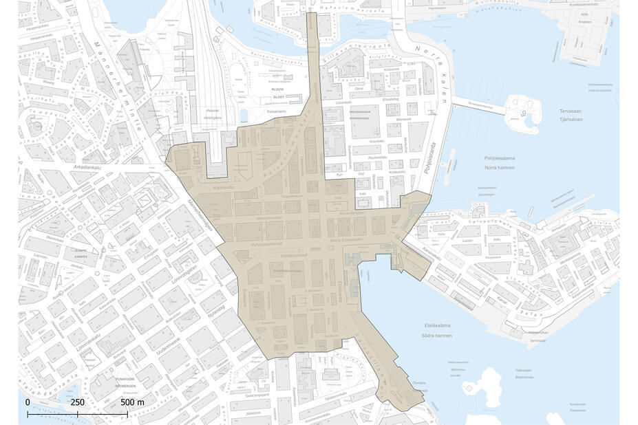
We are preparing a transport and urban space plan for Kluuvi and Kaartinkaupunki. The plan will determine aspects such as:
- how the existing pedestrian areas could be improved
- which will be the new sites where the comfort of urban space will be increased
- how to improve the efficiency of mobility for different modes of transport
- how maintenance traffic will be organised in the area
- how parking will be developed, and
- where adding more street greenery would be possible.
The main aim of the plan is to attract more people to the Helsinki city centre and make them stay there longer. At the same time, we will ensure that the city centre is accessible to people of all ages and abilities, and that it is an attractive employment area where people also enjoy coming to work onsite in the offices.
We aim to develop the residential streets in the area to ensure quiet traffic, low noise levels and safe streets for children and the elderly. Quiet residential streets allow crossing the street at any point. Residential streets would only have incoming and outgoing traffic, and thoroughfare traffic would be directed to main network streets such as the Esplanadi streets. The residential streets would also have residential parking.
The current planning will focus on the Kluuvi and Kaartinkaupunki area. The planning was started in spring 2025, when we conducted an online survey with a sample group of Helsinki residents and businesses in the area. This was accompanied by a series of discussion events for residents, businesses and other stakeholders in the area in April–May 2025. The plan is due to be completed in spring 2026. A similar plan for the Kamppi area is expected to be launched in 2026.

Project timeline
-
Winter 2025
Launching the planning process
-
Spring 2025
- Online survey for a sample group of Helsinki residents and businesses in the area in April
- Discussion events for local residents, businesses and other stakeholders in May
-
Autumn 2025
- Draft plans are ready
- Draft plans and planning officers available at Rikhardinkatu Library 27–28 October and at the University of Helsinki’s Urbarium on 6 November.
- Impact assessment is launched
-
Winter-Spring 2026
- Completion of the plan
- Urban Environment Committee’s processing in the spring
Starting points of the plan
Inner city’s transport system plan and development plan for land use as the basis of the plan
The Kluuvi and Kaartinkaupunki transport and urban space plan is a master plan based on the strategic-level land use and transport plans approved by the Helsinki City Board.
See previous plans:
The City of Helsinki’s City Strategy 2025–2029 states that a transport system plan for the city centre will be implemented during this strategy period. In the city centre transport system plan, the city centre was divided into smaller areas which all require their own master plan. One of these areas is the Kluuvi and Kaartinkaupunki area.
Kaivokatu will be developed as a public transport street, and transverse car traffic in the city centre will be concentrated on the Esplanadi streets.
In the transport system plan for the city centre, it was decided that Kaivokatu, Asema-aukio Square and Postikatu, as well as Simonkatu and Kansakoulukatu in Kamppi, would be designated as local streets with no through-traffic. The plans for Kaivokatu were based on the public transport option, where Kaivokatu is used only by trams, pedestrians and cyclists between Keskuskatu and Asema-aukio Square.
When Kaivokatu is removed from the main street network of the city centre, transverse car traffic will be concentrated on the Esplanadi streets. Further planning must take into account the smooth flow of transverse car traffic on the Esplanadi streets and their sufficient capacity, in particular in terms of sensitivity to disturbances, emergency services traffic, operational security and the efficiency of port traffic. A zoning change is currently underway on the Esplanadi streets, based on maintaining the current lane arrangements on the streets (two lanes in each direction).
Focus on improving comfort around the main railway station and Kaisaniemi
We carried out an online survey for a sample group of Helsinki residents during the initial stages of the plan, in spring 2025. The survey respondents felt that the streets, squares and parks around the main railway station and Kaisaniemi were the most unpleasant areas in the Kluuvi and Kaartinkaupunki areas of the city centre. This experience of unpleasantness was compounded by noise, unsafe feeling caused by traffic and high volumes of car traffic. The results of the survey are in line with those of several previous surveys carried out by the City. The operators and businesses in the area also considered these areas unpleasant, based on both a survey and a discussion event targeted at them.
Aim to increase the use of underground parking facilities
The transport system plan for the city centre decided to aim for an increase in the use of underground parking facilities. We are currently studying the possibility of building a new entrance to the central service tunnel from Hakaniemi and opening a link through the service tunnel to allow underground access from the eastern car parks to the western car parks. Promoting the use of underground parking facilities was supported in the discussion events of both the transport system plan for the city centre and the event held for the ongoing plan.